Rock weathering can counteract river CO<sub>2</sub> emissions induced by permafrost thaw
Nature News ·
Study area and field sampling Spanning about 30% of the entire QTP, this 780,000 km 2 study area is situated between the boundary of the Loess Plateau (Gansu Province, 103° E) and the border of China …
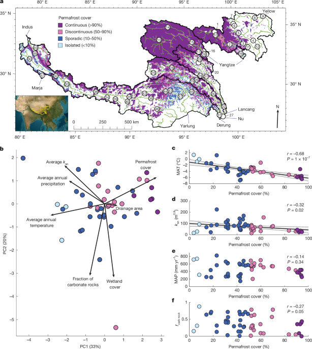
Study area and field sampling Spanning about 30% of the entire QTP, this 780,000 km 2 study area is situated between the boundary of the Loess Plateau (Gansu Province, 103° E) and the border of China (Tibet Autonomous Region, 78° E), and includes the headwater of eight major river basins: the Yellow, Yangtze, Lancang–Mekong, Nu–Salween, Derung (Irrawaddy), Yarlung Tsangpo–Brahmaputra, Marja Tsangpo (Ganges) and Indus Rivers (Fig. 1a and Supplementary Table 1 ). This region spans gradients of climate, topography, vegetation cover, permafrost extent and lithology, with elevations between 1,600 and 8,000 m above sea level. The rivers drain the major tectonic terranes of the QTP that contain a wide range of sedimentary, igneous and metamorphic rocks 51 , 52 (Extended Data Fig. 1b ). In the northeast of the study area, the Yellow and Yangtze Rivers drain marine carbonate and siliciclastic sediments of the eastern Kunlun–Qaidam Terrane and the Triassic deep-marine sediments of the Songpan–Ganzi flysch complex 51 . The Lancang, Nu and the southwestern Yangtze catchments drain mostly terrestrial siliciclastic and shallow marine carbonate rocks of the eastern Qiangtang and northern Lhasa Terrane 51 . In particular, the sediments of the Qiangtang Terrane contain abundant evaporites 45 . …
Original source: Nature News