Mining triggers extensive additional deforestation in sub-Saharan Africa
Nature News ·
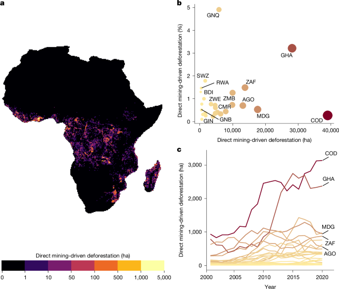
Data To map and analyse the spatial extent of direct mining-induced deforestation of dense forest across sub-Saharan Africa, we used previously published data 23 that map post-deforestation land use …
Data To map and analyse the spatial extent of direct mining-induced deforestation of dense forest across sub-Saharan Africa, we used previously published data 23 that map post-deforestation land use across sub-Saharan Africa between 2001 and 2020 at a resolution of 30 m. The dataset first used the global forest change data 24 to identify areas of forest loss between 2001 and 2020, before combining an active learning framework with high-resolution (5 m) Planet–Norway’s International Climate and Forests Initiative data to train a deep-learning model that predicts post-deforestation land use. Post-deforestation land use is assigned to one of 15 different classes by the model, one of which is mining. Mining is defined as land used for extractive subsurface and surface mining activities (such as underground and strip mines, quarries and gravel pits), including all associated surface infrastructure as described previously 23 . Mining as a post-deforestation land use is mapped with high accuracy, with a 98% user’s accuracy and an 82% producer’s accuracy (see ref. 23 for original accuracy metrics). We used all instances of mining mapped previously 23 to represent areas of mining activity in this analysis. The mining data are presented at a resolution of 30 m pixels, with pixels representing either direct mining-induced deforestation or not. It was thus important to group proximate mining pixels together to create distinct ‘clusters’ of mining activity for use in the analysis. …
Original source: Nature News