Nasa images show wildfire damage to island dubbed ‘Galapagos of California’
The Guardian World ·
Images from a Nasa satellite showcased the devastating scars left behind by a wildfire that consumed roughly a third of Santa Rosa Island, one of the five islands that make up Channel Islands …
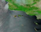
Images from a Nasa satellite showcased the devastating scars left behind by a wildfire that consumed roughly a third of Santa Rosa Island, one of the five islands that make up Channel Islands national park off the southern California coast. Taken on 20 May, the Moderate Resolution Imaging Spectroradiometer (Modis) took the false-color image of the burn area, showing swaths of blackened land. While the fire is mostly contained, the images drive home the potential lasting impact on the unique ecosystems across the rugged and remote island. Home to scores of rare and threatened species, Santa Rosa Island provides habitat to some plants and animals found nowhere else on earth. The fire that scorched more than 18,300 acres (7,400 hectares) is believed to be the largest recorded on the island, officials said. The landscapes that evolved separately from California’s mainland are not considered fire-adapted ecosystems, and blazes of this magnitude and size are uncommon here. While the cause of the fire is still under investigation, according to National Park Service officials, flames were spotted after a sailor crashed his boat onto Santa Rosa Island’s rocky shores and fired flares to seek help. Images shared by the coast guard showed that “SOS” was carved into the charred ground by the 67-year-old man before he was rescued by helicopter. …
Original source: The Guardian World
Mentioned
San Diego · California · U.S. Coast Guard · National Park Service