Farming in Ancient Lake Agassiz
NASA Breaking News ·
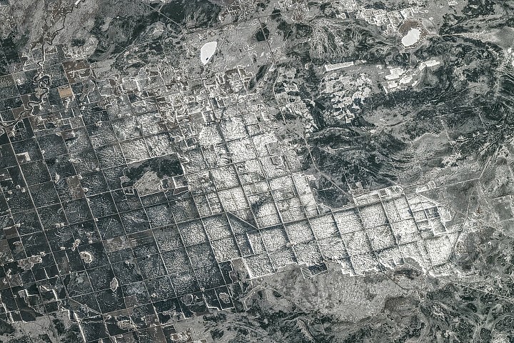
Editor's Note: Today's story is the answer to the May Puzzler . About 15,000 years ago, southeastern Manitoba sat beneath tens of meters of frigid water. …
Editor's Note: Today's story is the answer to the May Puzzler . About 15,000 years ago, southeastern Manitoba sat beneath tens of meters of frigid water. Lake Agassiz —which once encompassed present-day Lake Manitoba, Lake Winnipeg, and Lake of the Woods—covered an area larger than all of the Great Lakes combined. It formed in front of the retreating Laurentide Ice Sheet , which dammed rivers that otherwise might have drained into Hudson Bay, producing an expansive body of water 1,100 kilometers (700 miles) long by 300 kilometers wide that spanned parts of today’s Manitoba, Ontario, Saskatchewan, North Dakota, and Minnesota. The lake began draining roughly 12,000 years ago, but its legacy remains visible across the region. In April 2026, an astronaut aboard the International Space Station snapped this photograph of farmland along the southern shore of Lake Winnipeg, where Lake Agassiz once deposited a thick, nearly flat bed of nutrient-rich silt and clay. Former lakebed areas like this one now support some of Canada's most productive agricultural landscapes. A grid-based land survey has also left its mark. The Dominion Land Survey , one of the world’s largest and most systematic surveying efforts, divided much of western Canada into one-square-mile sections after the Canadian government purchased Rupert’s Land from the Hudson's Bay Company in 1869. The grid continues to define the layout of farm fields, roads, shelterbelts , and drainage channels. …
Original source: NASA Breaking News