Ahuachapán and Its Restive Neighbors
NASA Breaking News ·
Volcanic activity takes on many forms in western El Salvador. The land near the city of Ahuachapán is pockmarked with craters and covered with recent lava flows. …
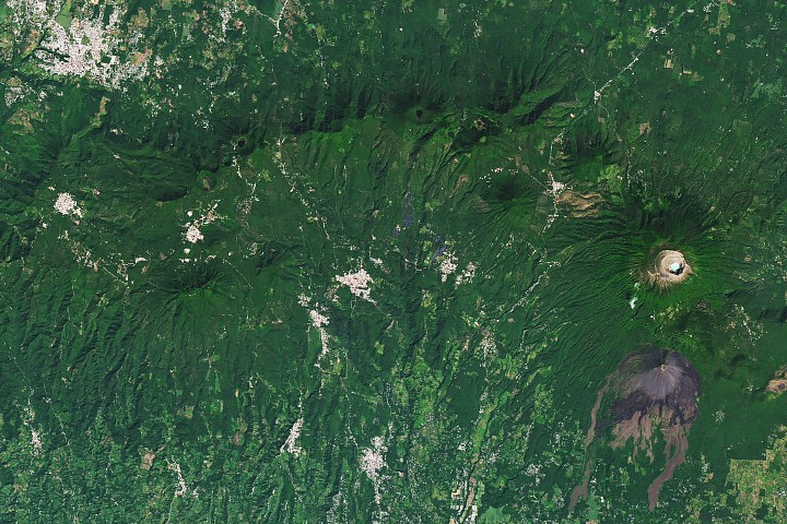
Volcanic activity takes on many forms in western El Salvador. The land near the city of Ahuachapán is pockmarked with craters and covered with recent lava flows. Meanwhile, a geothermal field feeds geysers, heats mineral pools , and powers a long-operating energy plant. The area is part of a volcanic landscape that stretches more than 1,000 kilometers (600 miles) along the Pacific coast from Guatemala to Panama, composing the Central American Volcanic Arc . On the right side of the image, Santa Ana stands at 2,381 meters (7,812 feet) above sea level as the country’s tallest volcano. Its summit features several crescent-shaped ridges surrounding a hot, acidic crater lake . The volcano remains active, with small to moderate explosive eruptions recorded since the 16th century. Its most recent significant eruption, in 2005 , launched a dense gas and ash column high in the air and sent lahars down its slopes. In 1770, another volcano began forming on Santa Ana’s southern flank. Izalco grew into a steep-sided stratovolcano through frequent eruptions over the next two centuries. Its regular activity—including Strombolian eruptions and lava fountains—earned it the nickname “Lighthouse of the Pacific,” as people at sea were reported to witness its glowing emanations. The “lighthouse” has since powered down, with Izalco’s most recent activity occurring in 1966. A line of forested, dimpled stratovolcano peaks arcing across the scene forms the Apaneca Range. …
Original source: NASA Breaking News